Sysolution GPS modem G10
Product Introduction:
G10 is a complete GPS&GLONASS&Galileo&QZSS engine
module that features super sensitivity, ultra low power and small
form factor. The GPS&GLONASS&Galileo& QZSS signal is
applied to the antenna input of module, and a complete serial data
message with position, velocity and time information is presented
at the serial interface with NMEA protocol or custom protocol.
Its – 165dBm tracking sensitivity extends positioning coverage into
place like urban canyons and dense foliage environment where the
GPS&GLONASS&Galileo&QZSS was not possible before. The
small form factor and low power consumption make the module easy to
integrate into portable device like DVR,UVA,Car trackers and PNDs.
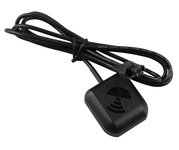
Product Image:
Applications
- UVA (unmanned aerial vehicle)
- DVR ( Digital Video Recording)
- Rear view mirror DVR
Car Tracker
Specifications :
| Type | Parameter |
| Main chip | MTK 3333 |
| Track sensitivity | -165dBm |
| Time to First Fix | Extremely fast at low signal level |
| Built in high LNA | YES |
| Power consumption | Max 40mA@3.3V |
| Protocol | NMEA-0183 compliant protocol or custom protocol |
| Operating temperature | -40 to 85C |
| Operating voltage | 3.0V to 5.0V |
| Module type | UART/TTL |
| Size | 45x38x13mm |
| Certification | RoHS compliant(Lead-free) |
| Power Supply | Supply voltage:3.0V~5.0V Typical : 3.3V | |
| Power Consumption | Acquisition:45mA @VCC=VBAT=3.3V Tracking:40mA @VCC=VBAT=3.3V Standby:2.0mA @VCC=VBAT=3.3V Backup:20uA @VBAT=3.3V | |
| Receiver Type | Code 66 search channels, 22 synchronous tracking channels
GPS&&QZSS L1 1575.42MHz C/A,GLONASS L1OF 1602MHz,GALILEO
E1B/C1, GLONASS L1OF 1602MHz, SBAS: WAAS, EGNOS, MSAS, GAGAN | |
| Sensitivity | Tracking: - 165d Bm Re-acquisition:- 156d Bm Acquisition:- 148d Bm | |
| TTFF (EASY enabled) | Cold start :15s typ @- 130d Bm Warm start : 5s typ @- 130d Bm Hot start :1s typ @- 130d Bm | |
| TTFF (EASY disabled) | Cold start(Autonomous):35s typ @- 130d Bm Warm start (Autonomous) :30s typ @- 130d Bm Hot start (Autonomous) :1styp @- 130d Bm | |
Horizontal Position Accuracy (Autonomous) | <2.5m CEP @- 130 dBm | |
| Max Update Rate | Up to 10Hz, 1Hz by fault | |
| Accuracy of 1PPS Signal | not enabled | |
| Acceleration Accuracy | Without aid: 0.1m/s2 | |
| Dynamic Performance | Maximum altitude: 18,000m Maximum velocity: 515m/s Acceleration: 4G | |
| UART Port | UART Port : TXD and RXD Supports baud rate from 4800bps to 115200bps, 9600bps by default UART port is used for NMEA output, MTK proprietary commands input
and firmware upgrade | |
| Temperature Range | Normal operation: -40°C ~ +85°C Storage temperature: -45°C ~ +125°C | |
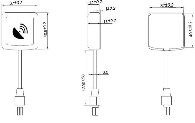
Physical Characteristics | Size: 45±0.20 × 38±0.20 ×13±0.50mm Connecting line specifications:Molex 2*2Pin , L= 130CM Weight: Approx. 98g | |
Power Supply
Regulated power for the G10 is required. The VCC Pin Need a stable
DC voltage supply. Power supply ripple must be less than 30mV. The
input voltage Vcc should be 3.0V~5.0V, Recommended power supply
voltage is 3.3V . maximum current is 45mA. Suitable decoupling must
be provided by external decoupling circuitry.
UART Ports
The module supports two full duplex serial channels UART. All
serial connections are at 3V CMOS logic levels, if need different
voltage levels, use appropriate level shifters. The baud rate of
both serial ports are fully programmable, the data format is
however fixed: X, N, 8, 1, i.e. X baud rate, no parity, eight data
bits and one stop bit, no other data formats are supported, LSB is
sent first. The modules default baud rate is set up 9600bps,
however, the user can change the default baud rate to any value
from 4800 bps to 115kbps. UART port can be used for firmware
upgrade, NMEA output and PMTK proprietary commands input.
Application
The module is equipped with a Molex 2*2Pin connects to your
application platform. The G10 module It consists of a MediaTek
MT3333 single chip GNSS IC which includes the RF part and Baseband
part, a patch antenna, a LNA, a SAW filter, a TCXO, a crystal
oscillator, Also comes with a 0.22F crystal capacitor ,can backup
satellite ephemeris about 2 hour.
PIN Definition:


| Pin No. | Pin name | I/O | Description | Remark |
| 1 | RXD | I | UART Serial Data Input | |
| 2 | GND | G | Ground | |
| 3 | TXD | O | UART Serial Data output | |
| 4 | VCC | I | Module Power Supply | Voltage range: 3.0V~5.0V |
Dimension:
NMEA 0183 Protocol
The NMEA protocol is an ASCII-based protocol, Records start with a
$ and with carriage return/line feed. GPS&GLONASS specific
messages all start with $GPxxx/$GLxxx where $GNxxx is a
three-letter identifier of the message data that follows. NMEA
messages have a check sum, which allows detection of corrupted data
transfers.
1. Location mode configuration instruction
Single system or dual system positioning mode can be selected
through the configuration instructions, configuration instructions
such as Table 1.
Table 1: Instruction configuration instructions
| Pattern | Instructions | NMEA Out Put |
| GPS | $PMTK353, 1,0*36 | GPRMC.GPGGA.GPGSV.GPGSA.GPGLL.GPVTG |
| GLONASS | $PMTK353,0, 1*36 | GLRMC.GLGGA.GLGSV.GLGSA.GLGLL.GLVTG |
| GPS&GLONASS | $PMTK353, 1, 1*37 | GNRMC.GNGGA.GPGSV.GLGSV.GPGSA.GLGSA. GNGLL.GNVTG |
The ASIR AGM-41G-33MX130initialization location mode for
GPS&GLONASS dual mode.
Output data :$GNRMC. $GNGGA. $GPGSV. $GLGSV. $GPGSA. $GLGSA.$GNGLL.
$GNVTG
2. NMEA-0183 data Detailed field
2.1. GGA-Global Positioning System Fixed Data
$xxGGA, 161229.487,3723.2475,N, 12158.3416,W, 1,07,
1.0,9.0,M.0000*18
Table 2: GGA Data Format
| Name | Example | Units | Description |
| Message ID | $xxGGA | | GGA protocol header |
| UTC Position | 161229.487 | | hhmmss.sss |
| Latitude | 3723.2457 | | ddmm.mmmm |
| N/S indicator | N | | N=north or S=south |
| Longitude | 12158.3416 | | dddmm.mmmm |
| E/W Indicator | W | | E=east or W=west |
| Position Fix Indicator | 1 | | See Table 2- 1 |
| Satellites Used | 07 | | Range 0 to 12 |
| HDOP | 1.0 | | Horizontal Dilution of Precision |
| MSL Altitude | 9.0 | meters | |
| Units | M | meters | |
| Geoids Separation | | meters | |
| Units | M | meters | |
| Age of Diff.Corr. | | second | Null fields when DGPS is not Used |
| Diff.Ref.Station ID | 0000 | | |
| Check sum | *18 | | |
| <CR> <LF> | | | End of message termination |
Table 2-1: Position Fix Indicators
| Value | Description |
| 0 | Fix not available or invalid |
| 1 | GPS&GLONASS SPS Mode, fix valid |
| 2 | Differential GPS&GLONASS, SPS Mode, fix valid |
| 3 | GPS&GLONASS PPS Mode, fix valid |
- GLL-Geographic Position – Latitude/Longitude
$xxGLL , 3723.2475, N, 12158.3416, W, 161229.487, A*2C.
Table 3: GLL Data Format
| Name | Example | Units | Description |
| Message ID | $xxGLL | | GLL protocol header |
| Latitude | 3723.2475 | | ddmm.mmmm |
| N/S Indicator | N | | N=north or S=south |
| Longitude | 12158.3416 | | dddmm.mmmm |
| E/W Indicator | W | | E=east or W=west |
| UTC Position | 161229.487 | | hhmmss.sss |
| Status | A | | A=data valid or V=data not valid |
| Check sum | *2C | | |
| <CR> <LF> | | | End of message temination |
- GSA-GNSS DOP and Active Satellites
$xxGSA , A, 3, 07, 02, 26,27, 09, 04, 15, , , , , , 1.8, 1.0,
1.5*33.
Table 4: GSA Data Format
| Name | Example | Units | Description |
| Message | $xxGSA | | GSA protocol header |
| Mode 1 | A | | See Table 4-2 |
| Mode 2 | 3 | | See Table 4- 1 |
| Satellite Used | 07 | | Sv on Channel 1 |
| Satellite Used | 02 | | Sv on Channel 2 |
| … | … | | … |
| Satellite Used | | | Sv on Channel 66 |
| PDOP | 1.8 | | Position Dilution of Precision |
| HDOP | 1.0 | | Horizontal Dilution of Precision |
| VDOP | 1.5 | | Vertical Dilution of Precision |
| Check sum | *33 | | |
| <CR> <LF> | | | End of message termination |
Table 4-1: Mode 1
| Value | Description |
| 1 | Fix not available |
| 2 | 2D |
| 3 | 3D |
Table 4-2: Mode 2
| Value | Description |
| M | Manual-forced to operate in 2D or 3D mode |
| A | Automatic-allowed to automatically switch 2D/3D |
- GSV-GNSS Satellites in View
$xxGSV , 2, 1, 07, 07, 79,048, 42, 02, 51,062, 43, 26, 36,256, 42,
27, 27, 138,42*71
$xxGSV, 2, 2, 07, 09, 23,313, 42, 04, 19, 159, 41, 15, 12,041,
42*41.
Table 5: GSV Data Format
| Name | Example | Units | Description |
| Message ID | $xxGSV | | GSV protocol header |
| Number of Message | 2 | | Range 1 to 3 |
| Message Number | 1 | | Range 1 to 3 |
| Satellites in View | 07 | | |
| Satellite ID | 07 | | Channel 1(Range 1 to 66) |
| Elevation | 79 |  egrees egrees | Channel 1(Maximum 90) |
| Azinmuth | 048 |  egrees egrees | Channel 1(True, Range 0 to 359) |
| SNR(C/NO) | 42 |  BHz BHz | Range 0 to 99,null when not tracking |
| … | | | … |
| Satellite ID | 27 | | Channel 4(Range 1 to 66) |
| Elevation | 27 |  egrees egrees | Channel 4(Maximum 90) |
| Azimuth | 138 |  egrees egrees | Channel 4(True, Range 0 to 359) |
| SNR(C/NO) | 42 |  BHz BHz | Range 0 to 99, null when not tracking |
| Check sum | *71 | | |
| <CR> <LF> | | | End of message termination |
Depending on the number of satellites tracked multiple messages of
GSV data may be required.
- RMC-Recommended Minimum Specific GNSS Data
$xxRMC, 161229.487, A, 3723.2475, N, 12158.3416, W, 0. 13,309.62,
120598,, *10
Table 6: RMC Data Format
| Name | Example | Units | Description |
| Message ID | $xxRMC | | RMC protocol header |
| UTS Position | 161229.487 | | hhmmss.sss |
| Status | A | | A=data valid or V=data not valid |
| Latitude | 3723.2475 | | ddmm.mmmm |
| N/S Indicator | N | | N=north or S=south |
| Longitude | 12158.3416 | | dddmm.mmmm |
| E/W Indicator | W | | E=east or W=west |
| Speed Over Ground | 0. 13 | Knots | |
| Course Over | 309.62 | Degrees | True |
| Ground | | | |
| Date | 120598 | | ddmmyy |
| Magnetic variation | | Degrees | E=east or W=west |
| Check sum | *10 | | |
| <CR> <LF> | | | End of message termination |
- VTG-Course Over Ground and Ground Speed
$xxVTG, 309.62, T, M, 0. 13, N, 0.2, K*6E
Table 17: VTG Data Format
| Name | Example | Units | Description |
| Message ID | $xxVTG | | VTG protocol header |
| Course | 309.62 | Degrees | Measured heading |
| Reference | T | | True |
| Course | | Degrees | Measured heading |
| Reference | M | | Magnetic |
| Speed | 0. 13 | Knots | Measured horizontal speed |
| Units | N | | Knots |
| Speed | 0.2 | Km/hr | Measured horizontal speed |
| Units | K | | Kilometer per hour |
| Check sum | *6E | | |
| <CR> <LF> | | | End of message termination |